


Rivercast - River Levels App
4.678.00 Reviews
App Specs
- Version
- 3.59
- Updated On
- License
- Free
- Downloads
- 10,000+
- Developer
- Juggernaut Technology, Inc.
- Categories
- Weather
- Platform
- Android
Screenshots
 Analysis by AppCompare
I find that river information becomes most useful when I know what decision I’m trying to make. A reading can help me decide whether to postpone a riverside walk, check conditions before fishing, or look into a river before setting out on a longer trip. Rivercast is aimed at that practical niche rather than at general weather watching, and that focus is both its appeal and the first thing I’d consider before installing it.
Where a river app can feel confusing
The main point of friction with any river-level app is not necessarily finding a reading; it is knowing whether you have found the right place. A river may pass through several towns and include multiple monitoring locations, so a nearby result is not automatically the station that best represents the stretch you plan to visit. I would check the station’s location and make sure it corresponds to the part of the river I care about before relying on its information.
That distinction matters especially when planning an outing with other people. A reading from upstream can be useful context, but it is not a guarantee of conditions farther downstream. I treat the app as a way to inform a decision, not as a substitute for checking local conditions at the destination. This is a sensible habit whether I am taking a short walk by the water or arranging a more demanding activity.
Checks that make the first session easier
When opening a river app for the first time, I’d start by searching for a familiar river or location rather than immediately allowing location access. That gives me a chance to see whether the results make sense and to choose a useful station deliberately. If I am somewhere unfamiliar, location-based discovery can save time, but I still review the result instead of assuming the closest option is the right one.
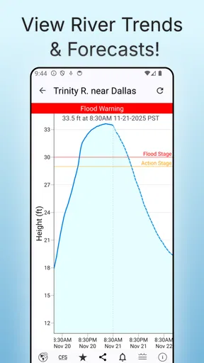
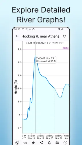
I would also look at the available history before deciding what a current reading means. A number on its own can be hard to interpret; seeing how it compares with earlier readings gives me a better sense of whether the river is relatively steady or changing. That comparison is useful for planning, but it should not be mistaken for a prediction of what will happen next.
For an outing I care about, I would check the river in advance and again closer to departure. That simple routine helps me avoid treating an old glance as a current assessment. If I use alerts, I would regard them as a prompt to check the app again, not as a reason to stop paying attention to weather and conditions where I am going.
Recovering when a result seems unhelpful
If a search does not show the location I expected, I would try a broader river name or a nearby town and compare the resulting stations. Names can be less obvious than a map makes them look, and searching one stretch may not surface the station I had in mind straight away. When a result looks unfamiliar, checking its location is a better next step than choosing it simply because it appeared first.
Worth Reading Before You Choose

EA SPORTS FC Mobile 26 Is a Bigger Football Game, but It Takes Time

Flipboard Shows What News Apps Must Do Beyond the Feed

Switching to Android Auto Means Rethinking Your Driving Routine

Google Calendar Makes a Crowded Week Easier to Manage

Ludo King Makes the Most of the Minutes Between Plans

Baby Panda World Brings Quick Play to Modern Phones, but Its Game Library Feels Busy
If a reading looks surprising, I would refresh my understanding of the situation before drawing conclusions: check that I have the right station, look at its history, and compare what the app shows with conditions around my destination. A discrepancy does not automatically mean the app is malfunctioning. Different sections of a river can behave differently, and the information available for one station may not describe another stretch.
Knowing what the app can and cannot settle
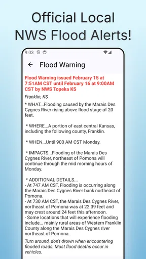
River levels are only one part of deciding whether an outdoor plan is sensible. Weather, access, local hazards, and the needs of the people in your group matter too. I would not use a river reading alone to decide that boating or swimming is safe, and I would not treat an alert as an emergency warning. For safety-critical choices, local guidance and direct observation deserve more weight than a single app screen.
This is also where the app’s specialised focus becomes a trade-off. A general weather app is usually more convenient for checking a broad forecast, while a dedicated river tool makes more sense when water levels are central to the plan. I would keep using a regular forecast for rain and conditions around the trip, then use Rivercast to look at river information. Neither view replaces the other.
Who will get the most from it
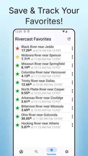
I think it suits people who return to the same river, plan fishing or boating outings, or simply want a more informed picture before visiting a waterside spot. A useful habit is to save the stations you check repeatedly, then compare their histories when planning around changing conditions. That reduces repeated searching and makes it easier to notice context, though it still leaves the responsibility of checking that each saved station matches the intended stretch.
For example, if I were planning a weekend fishing trip, I would choose the relevant station during the week, review its past readings, and check it again before leaving. If the situation appeared to have changed, I would rethink the plan and consult local information rather than assuming that a familiar location always behaves the same way. That is a practical workflow for making better-informed plans, not a promise that the app can forecast every change.
It may be less useful if I only want a city forecast, rarely visit rivers, or expect one reading to tell me whether an entire river is safe. In those cases, a standard weather app or local safety information is a better starting point. I would also avoid relying on river information while offline unless I had already confirmed that what I need is available; checking before travel is the safer approach.
Getting to Know Rivercast
First off, the Rivercast - River Levels App is a nifty tool for anyone who needs real-time data about river levels and flow rates. Whether you’re a boater, fisherman, or just someone who enjoys a good riverside picnic, this app has got you covered. It's available for both Android and iOS, which is great because no one gets left out!
Setting Up the App
Installation was a breeze. A quick download from the app store, and I was ready to go. The interface is straightforward, which I appreciate. No one wants to spend hours trying to figure out how an app works, right?
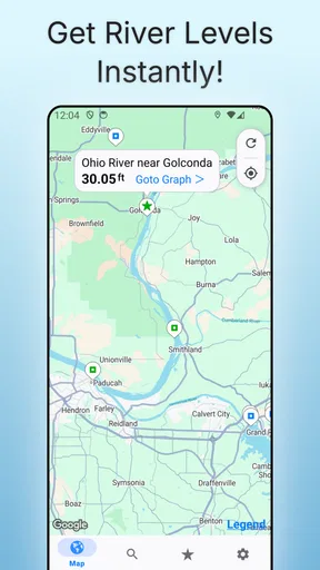
Once you open the app, you’re greeted with a simple homepage that gives you the option to search for rivers by name or location. You can also let the app use your GPS to find the nearest rivers, which is super convenient if you’re out on the road.
Features Worth Highlighting
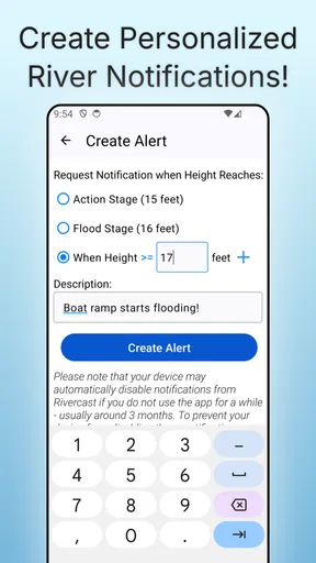
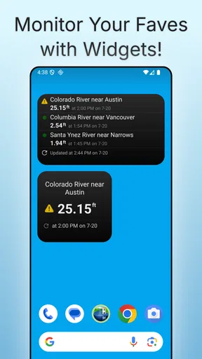
One of the standout features is the real-time updates on river levels. You get data straight from the USGS, which means it's as accurate as it gets. You can set up alerts for your favorite rivers, so you’ll get a notification if the water level changes drastically. This is perfect for those who need to plan activities around the water.
Another cool feature is the historical data. If you're into data analysis or just curious about how a river's behavior changes over time, this feature will be right up your alley. You can check past water levels and compare them with current data to get a better understanding of the river's patterns.
User Experience
The app runs smoothly without any noticeable glitches. I’ve used it several times now, and it hasn’t crashed on me yet, which is always a plus in my book. The design is clean, and navigation is intuitive. Even if you’re not tech-savvy, you’ll find it pretty easy to get the hang of things.
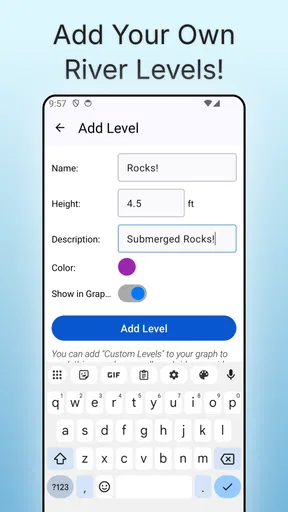
One little thing that might be worth noting is that the app could use a bit more customization options. While the alerts and favorites are handy, having a few more personal touches could enhance the user experience a bit more.
Why You Might Love It
If you’re someone who plans outdoor activities based on river conditions, this app is practically a must-have. The real-time data ensures you’re always in the loop, which can be crucial for safety and planning. Plus, knowing the river conditions can help you make the most of your adventures.
The historical data feature is a bonus for those who love diving into details. Whether you're tracking seasonal changes for fishing or just curious about how climate affects river levels, this app provides a treasure trove of information.
Wrapping It Up
Overall, the Rivercast - River Levels App serves a niche but essential purpose for outdoor enthusiasts and professionals alike. It's user-friendly, reliable, and packed with valuable features. While it could use a few more personalization options, it delivers where it counts: real-time, accurate river data.
So, if you’re someone who needs to keep a close eye on river levels, this app is definitely worth checking out. Happy adventuring!
In practical terms, I’d start with the free version and see whether the rivers I care about are easy to find and whether the information fits my routine. The app is made by Juggernaut Technology, Inc., and its 4.6 average from 583 ratings suggests that many people find it useful, although a rating cannot tell me whether it covers my particular stretch of water. It has 10K+ installs, is rated for Everyone, and version 3.53 requires iOS 11 or later. The app is free to get, with in-app purchases ranging from $9.99 to $39.99 per item, so I would check what any purchase offers before paying rather than assuming the core river checks require an upgrade.
For someone checking one familiar river, the value is straightforward: keep a few relevant places handy, look at their history, and return to them before outings. For someone who travels widely, station selection may take more thought each time, and I would not assume that a saved location is a complete picture of a whole watershed. The best use is focused: identify the section that matters, use the available readings as context, and combine them with local knowledge.
How I’d fit it into a real day
Imagine I have a free afternoon and want to walk beside a river after rain. I’d check the local forecast separately, open Rivercast to review the station nearest the route, and compare its recent history rather than reacting to a single figure. If the reading seemed unusual, I’d verify that I selected the right stretch and look for current local guidance before leaving. On arrival, I’d still pay attention to what I can see on site. That workflow uses the app for what it does well without asking it to answer questions it cannot settle by itself.
There is a useful distinction between planning and monitoring. Before a trip, historical information can help me understand the background and choose whether the outing deserves another check. During a trip, a phone notification can be convenient, but it is not a replacement for a plan, good judgment, or appropriate safety information. I would set alerts for places I genuinely care about, not every nearby river; otherwise, notifications may become noise and lose their value.
What I’d compare before choosing it
Compared with the usual all-purpose weather app, Rivercast is the more relevant choice when the water itself is the focus. A general forecast is better for checking rain, temperature, or the broader conditions for a day outdoors; it may not give the same river-centred view. Conversely, if I only need to know whether to bring a jacket, opening a specialised river app is extra effort. I see them as complementary tools, not competing replacements.
Against checking a river website or other local source, the app’s advantage is having search, saved places, alerts, and historical information gathered in a mobile workflow. The trade-off is that convenience does not remove the need to confirm the specific location and interpret the reading sensibly. If the app does not surface the station I need, or if a decision has safety consequences, I would go directly to authoritative local information rather than spend time forcing a poor match.
My practical verdict
Rivercast is worth considering if river levels regularly affect your plans, especially if you revisit the same waterways and want an easy way to check current and past conditions. Its focused tools are more useful for that job than a generic forecast, while the straightforward search and location options make it approachable for occasional checks. The main work still belongs to the user: choose the right station, understand that conditions vary by stretch, and use other sources for weather and safety.
I would skip it if I rarely go near rivers or expect it to provide a complete outdoor safety assessment. For everyone else, my recommendation is to try it with one familiar river first, confirm that the station is relevant, and build a simple checking routine before relying on it for plans. That gives a fair sense of whether its specialised approach earns a place on your phone.
Pros
- Accurate river level updates.
- User-friendly interface.
- Customizable alerts.
- Covers multiple locations.
- Detailed weather forecasts.
Cons
- Limited offline functionality.
- Ads can be intrusive.
- Requires internet connection.
- No social sharing features.
- Occasional data refresh delays.
FAQs for Rivercast - River Levels App
What is Rivercast and how does it work?
Rivercast is a mobile application designed to provide real-time river level data and forecasts. It works by pulling information from various weather and hydrological sources to offer accurate updates. Users can monitor current river levels, set alerts for specific conditions, and view historical data to better understand trends and potential flood risks.
Is Rivercast available for both Android and iOS devices?
Yes, Rivercast is available for download on both Android and iOS platforms. You can easily find it on the Google Play Store for Android devices and the Apple App Store for iOS devices. This ensures that users across various mobile platforms can access its features and stay informed about river conditions.
Does Rivercast require an internet connection to function?
Yes, Rivercast requires an internet connection to access real-time data and updates. The app pulls information from online databases to provide accurate and up-to-date river levels and forecasts. Without an internet connection, users may not receive the latest updates, which could affect the reliability of the information provided.
Can I set custom alerts for river levels in Rivercast?
Absolutely, Rivercast allows users to set personalized alerts for specific river levels or conditions. This feature is particularly useful for those living in flood-prone areas or for outdoor enthusiasts who need to monitor river conditions for safety. Alerts can be customized based on user preferences for time, location, and river thresholds.
Is there a cost associated with using Rivercast?
Rivercast is free to download and use, but it may offer in-app purchases or a premium version for additional features. These could include ad-free use, advanced data analytics, or enhanced alert options. Always check the app's listing in the store for the most current information on pricing and available features.


